Kildare County Council partners with Azimap to plan public services
Kildare County Council is one of the main satellite counties of Dublin, with a large commuting population. The overall objective of the council is to maximise collective knowledge, contacts and expertise to plan strategically and co-ordinate service delivery in an integrated, efficient and effective manner.
PROJECT NAME
Migration from a desktop GIS to web GIS
PROJECT OUTCOMES
Transform and improve existing business processes associated to the visualisation, presentation and analysis of spatial data.
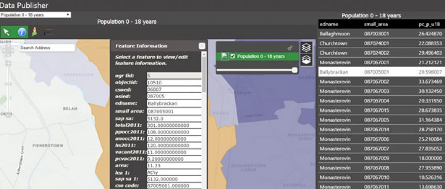
HOW AZIMAP WAS USED TO FULFIL PROJECT REQUIREMENTS?
Prior to 2015, Kildare Council was dependent on a desktop proprietary GI application to capture, visualise and analyse their spatial data. This was further supplemented with active-x based web services to publish and share data with internal stakeholders and the wider community.
This process was not intuitive and resulted in GI professionals working independently with poor communication with their peers.
After an initial consultation phase, which included multiple requirements gathering workshops to understand existing workflows, the Azimap project delivery team worked closely with Kildare County Councils project manager to document and define project requirements to ensure the migration project was delivered on time and within budget.Following the requirements gathering, consultancy and delivery phase, Azimap delivered a series of knowledge transfer sessions, to ensure key project members had the required skills to -
- Migrate existing spatial data from legacy systems
- Visualise, analyse and publish of their spatial data on dynamic web maps
- Create custom visualisations of their spatial data and embed them onto a web page or share the web map with alternative departments
- Create a centralised repository for all spatial data
- Work remotely from any locations on any device
- Embed GIS across all departments, to support decisions based on the key interests of its community
- Publicly share visual representations of spatial data with the citizens of Kildare
BENEFITS OF AZIMAP
- Opportunity to integrate with multiple data sources from various departments
- Enterprise pricing model as opposed to costs based on user license fees
- It has been developed on a .net framework around open source technologies including GeoServer and OpenLayers
- Flexible and scalable, enabling the application to be customised to meet specific requirements
- Integrates with what3words which is beneficial as Ireland has only recently created a post code system
- Support multiple editors administrating data at any one time
- Opportunity to create custom visualisations of their spatial data and embed them onto a web page or share the web map with alternative departments
- Direct access to a dedicate account manager, online support desk and support team
Azimap continue to work in partnership with Kildare County Council to improve operational efficiencies, reduce lead times, publish and share spatial data for both public and private consumption.
Explore Kildare County Council sample public facing map