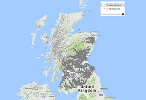
Species Conservation and Grey Squirrel Control Areas in Scotland
Using data published by the Forestry Commission locate the species conservation areas in Scotland.
This community map was created by importing two Shape files to create the two layers as seen on the map.
Both imported files contained the spatial data and associated metadata for areas to support the targeted control of grey squirrels in areas where they are a threat to the red squirrel population.
Upon importing the Shape file the EPSG was automatically configured to 3857 and when selecting show on map the data was displayed as polygons as expected providing the map administrator with the opportunity to style the features.
This community map has been presented on a Bing Aerial baselayer and the administrator has configured the what3words, Google Street View, Place Buffer and search tools on the toolbar.
This is another great example of how our community use Azimap to quickly create and share the maps that matter to them.
Data Source
How to import a Shape file into Azimap
Administrators can quickly import a Shape file into Azimap by dragging and dropping a zip folder or the contains of the folder into Azimap. Alternatively administrators can use the conventional method to upload files.
Upon importing your Shape files the EPSG will be automatically populated from our database of more than 6000 supported worldwide projections. After the import is complete the user can return to the data catalogue or select view on a map where they can proceed to style their layers.
If you require assistance when importing your data email support@azimap.com or request a personalised demonstration to help you get started.