GIS for Agriculture
GIS can help eliminate the guesswork out of the crop planning and infection management
Azimap GIS, web based mapping software can help eliminate the guesswork out of crop planning and infection management. Using GIS to map geographic and geologic features, scientists and farmers can work together to create more effective and efficient farming techniques.
Using Azimap GIS, scientists can digitise data to analyse soil records and combine them with historical farming practices to determine the best crops to plant and how best to maintain soil nutrition for the benefit of the plants.
Many organisations, including an EU member state public body use Azimap web GIS to maintain data quality and reporting. In addition, agriculture authorities can use Azimap's API to seamlessly integrate with existing processes and infrastructure.
The benefits of GIS within the Agriculture sector are immense, especially for farmers who are affected by adverse weather conditions to help with crop management.
Another key benefit of Azimap Web GIS is the ability to import imagery as a baselayer which can be published and shared securely with all stakeholders.
Discover how Azimap can benefit the agriculture sector by requesting a personalised demo or by signing up to a free trial.
Interactive Case Studies

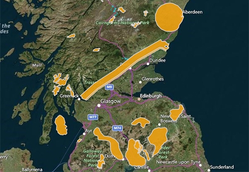
Species Conservation and Grey Squirrel Control Areas in Scotland
Locate the grey squirrel control and species conservation areas within Scotland.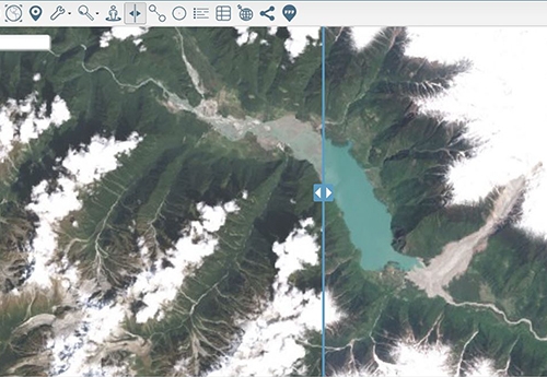
Layer Swipe Map of Zhamu Creek Landslide
One of the world's largest recorded landslides occurred at Zhamu Creek in Eastern Tibet.
Envo-GEO partners with Azimap to display LiDAR feature recognition
Envo-Geo use Azimap to evaluate the potential for dissemination and spatial analysis of LiDAR data.