


News
Home | News

Azimap Secures Place on Smart Belfast Collaborative Challenge
5th Dec 2017
We’re delighted to announce that we have secured a placed on the Smart Belfast Collaborative Challenge.

Azimap Shines at Mid Ulster Business Awards
23rd Nov 2017
We are delighted to announce that we scooped the award for Best Digital Initiative and Use of Social Media at the Mid Ulster Business Awards.
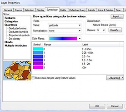
Preparation of OPW Fluvial Flood Extent & Depth Data
13th Nov 2017
Prepare the CFRAMS (Catchment Flood Risk Assessment and Management) mapping deliverables from the Office of Public Works (OPW) for Kildare County Council for consumption by Local Authority staff on their native GIS.

Azimap Announced As Finalist In Two Categories In The Mid Ulster Business Awards
31st Oct 2017
We are delighted to announce that Azimap has been shortlisted as a finalist within the Excellence in Innovation and Best Digital Initiative and Use of Social Media categories in the Mid Ulster Business Awards.

Celebrate GIS Day 2017
24th Oct 2017
GIS Day provides an international forum for users of geographic information systems (GIS) technology to demonstrate real-world applications that are making a difference in our society.


