As we continue our commitment to the ongoing development of Azimap, we are delighted to share with you some of the details of the new feature enhancements, which we believe will significantly improve your Azimap experience.
The Autumn release focuses on improving user experience and the continued development of a set of core web mapping features to empower our new and existing customers to quickly visualise and analyse their spatial data. These new features include:
UTF Interactivity
Once your map has thousands, if not millions, of attributes to interact with, it's no longer acceptable to have users download all the data and cache it in the browser, as it's too large and very time-consuming.
In an attempt to ensure an optimum experience and to avoid unnecessary data loading times, we are delighted to announce the release of UTF Interactivity. The main benefit of the UTF Interactivity for our customers is that UTF can handle and display feature information in real-time without delay.
To use the new UTF Interactivity, simply configure your feature information to appear on hover.
Pop-Up Enhancements
Following requests from our existing customers, it became evident that you did not want to display the same feature information for both on-click and hover actions. As such, administrators can now configure the feature information to display the data they want to show, based on either a click or hover action. Thus providing greater control over the presentation of map information.

We are also delighted to announce that administrators can now configure the pop-up theme, choosing between light or dark and horizontal or vertical alignment. This enhancement enables map publishers to have greater flexibility and control over the presentation of the feature information.
Finally, within the new pop-up tool-tip configuration, map publishers can now choose which properties in their data are searchable. This enhancement is beneficial for users who work in planning and need to quickly search by a planning reference number.
Advanced Layer Search
To complement the enhanced feature pop-ups, we have extended the search capabilities to enable users to refine their search parameters by focusing on key attributes such as starts with, contains or exact phrase match. Extending search capabilities enables both administrators and users to locate a feature within their data set quickly.
To try the new advanced layer search feature, select the search feature within your toolbar and then select search columns. Upon completing this action, a side panel will appear, where you can define the parameters of your search query, including whether it starts with, contains, or is exact, keeping in mind that the results returned will only return results from the data from the fields that you have defined as searchable.
Zoom to Layer
So, what happens when you have configured your map layers to only appear at a defined zoom level? You manually have to zoom in and out of the defined layer in order to see the lay data. This is not an intuitive experience for the user, as the layer appears to contain no data by default. To avoid the need to manually zoom to view a layer's details, we have extended the layer feature option to zoom to the layer location with a single click. This enables you to visualise your spatial data quickly and removes the need for multiple clicks.
Please note that the 'Zoom to Layer' feature currently does not support WMS searches. However, we are in the process of extending this functionality, which will be deployed as part of the Winter roadmap release.
Report Information
Ensuring the accuracy of your data is critical to ensuring the authenticity of the spatial data you're analysing and presenting on your web map. To help maintain optimal accuracy in your data, we have integrated Report Information capabilities, which are accessible through the feature information pop-in, as shown below.
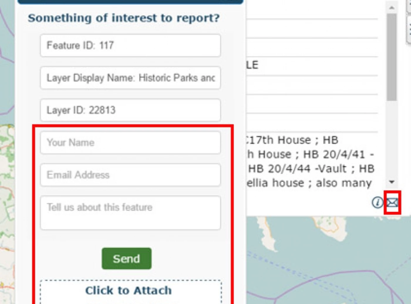
The Report Information form enables administrators to maintain the accuracy of their data by crowdsourcing the authenticity from their stakeholders. When a report is logged by a stakeholder, the map administrator will be alerted via email of the feature details reported by the stakeholder and the discrepancies in the data. The reporter can also upload supplementary evidence in the form of a PDF, JPG, PNG, CSV, XL or Word file.
Mobile Optimisation
Being able to manage and visualise spatial data across mobile, tablet, and desktop devices is extremely important to us, which is why we are committed to the ongoing development of Azimap to ensure you have an optimal experience across all devices.
To support this commitment, we have enhanced the mobile experience by including additional map details in the list view, allowing administrators to quickly locate and edit their map from any location. We have also redesigned the map definition and information pop-ups to ensure you have an optimum experience when editing your map on a mobile or tablet.
Closing notes
We are committed to the ongoing development of Azimap and are currently planning the Winter roadmap release, details of which will be announced within the coming weeks.
However, why not try the latest feature enhancements by signing up for a free 30-day trial of Azimap or by requesting a personalised demonstration?